This article is published under a Creative Commons license and not by the author of the article. So if you find any inaccuracies, you can correct them by updating the article.

New permafrost feature - deep crater in central Yamal (west Siberia, Russia) as a response to local climate fluctuations


Marina О. Leibman
Alexander I. Kizyakov
Andrei V. Plekhanov
Irina D. Streletskaya
Published: Jan. 1, 2014
Latest article update: Nov. 18, 2022
This article is published under the license


Abstract
This paper is based on field data obtained during short visits to a newly formed permafrost feature in a form of relatively narrow, deep crater. Excluding impossible and improbable versions of the crater's development, the authors conclude that it originated from warmer ground temperatures and an increase in unfrozen water content, leading to an increase in pressure from gas emissions from permafrost and ground ice. This conclusion is also supported by known processes in the palaeo-geography of Yamal lakes and recent studies of gas-hydrate behavior and subsea processes in gas-bearing provinces.
Keywords
Cryopegs, tabularground ice, pockmarks, cryolithozone, Yamal crater, pingo, gas hydrates, climate fluctuations
INTRODUCTION
This paper is based on field data obtained during short visits to a newly formed permafrost feature: a relatively narrow, deep crater. As new features like this have been reported recently in a number of massmedia publications, the processes leading to their formation may already be underway elsewhere in the region, making the study of their origin an urgent task.
Our field study included size measurements and photo and video documentation of the feature and the surrounding environment. The main objective of the reconnaissance was to outline the range of possible hypotheses of the crater's formation, to exclude impossible and improbable versions of its development, and to lay a basis for predicting such processes in the future.
No landform like the crater in Central Yamal discussed in this paper has been reported previously. Yet similar forms, seabed pockmarks, have been known and discussed since the 1970's [Hovland and Judd, 1988; 1992; Hovland et al., 2002; Mironyuk and Otto, 2014].
It is established that permafrost prevents the migration of methane from deep-seated hydrocarbon collectors into the upper permafrost and to the surface [Skorobogatov et al, 1998; Rivkina et al, 2006]. Concentration of methane in frozen Quaternary deposits in the Arctic depends on the age, origin and lithology of the permafrost. The gas and gas-hydrate accumulations are localized in the organic-rich horizons [Rivkina and Gilichinsky, 1996; Rivkina et al., 2006].
The authors' main hypothesis for the crater's formation involves the decay of relict gas- hydrate inclusions, the release of gas out of initially frozen deposits enclosing cryopegs and tabular ground ice. This assumption is based on the known cryolithology and geochemistry of permafrost in the region, with most of the studies performed in the Bovanenkovo gas field investigations [Streletskaya and Leibman, 2003]. The Bovanenkovo studies revealed substantial gas concentrations [Chuvilin, 2007; Yakushev, 2009], which are blocked by the permafrost [Rivkina et al., 2006; Gilichinsky et al., 1997].
The possibility of the release of the gas from the collectors near the surface is shown by methane and hydrogen sulfide effusion under the Barents and Kara seas from 70 to 130 m beneath the sea floor [Rokos, 2009]. Boreholes at Bovanenkovo gas field [Chuvilin, 2007] revealed various gas manifestations, such as emission out of the borehole and high content in the samples, in the depth interval 20 to 130 m. Most of the gas was contained in ice-bearing clays [Yakushev, 2009]. These clays also enclosed tabular ground ice, cryopegs and some voids filled with low-density ice.The maximum gas emission was 14,000 m3/day [Bondarev et al., 2008]. F. Are (1998) also suggests that gas accumulates in voids within the permafrost.
Studies of gas bubbles in tabular ground ice of the Kara sea region have shown concentrations of methane exceeding that of the atmosphere by an order of magnitude [Lein et al., 2003; Leibman et al., 2003; Streletskaya et al., 2014; Vanshtein et al., 2003]. Analysis of §C13(CH4) in the upper layers of permafrost in Bovanenkovo area returns results around - 70%, indicating a biochemical origin of this gas in organic matter in the permafrost. [Bondarev et al., 2008].The isotopic composition is within the same range as in tabular ground ice bubbles [Lein et al., 2003; Vanshtein et al., 2003; Cardyn et al., 2007; Streletskaya et al., 2014].
Methane concentration in modern marine sediments may exceed 1 ml/l in the Arctic seas, [Mironyuk and Otto, 2014] while even more than 0.1 ml/l is considered a high concentration [Hovland et al., 2002]. The methane concentration measured in the frozen deposits of coastal exposures on the Yamal can reach 1.7 ml/kg and in tabular ground ice even more, as much as 2.2 ml/kg [Streletskaya et al., 2014].
The release of this gas could be triggered by changes in ground temperature. Ground temperature changes result from fluctuations in both air temperature and snow accumulation. Warmer air can trigger the rapid changes on the surface, thaw ground ice bodies and create thermal denudation landforms (thermocirques) and thermokarst lakes. Probably, the new features found in 2014 result from the same rise of air temperature, but presenting a new mechanism of formation: gas release in the permafrost.
Thus the origin of the Yamal crater hypothesized in this paper is based on the analysis of (a) existing features resulting from gas-release processes in the Kara sea region as analogues of the observed onshore landform, (b) climate fluctuations that could have caused changes in thermal state of permafrost, and (c) comparison to other landforms connected to tabular ground ice, the salinity of the deposits, and the concentration of organic matter.
STUDY AREA
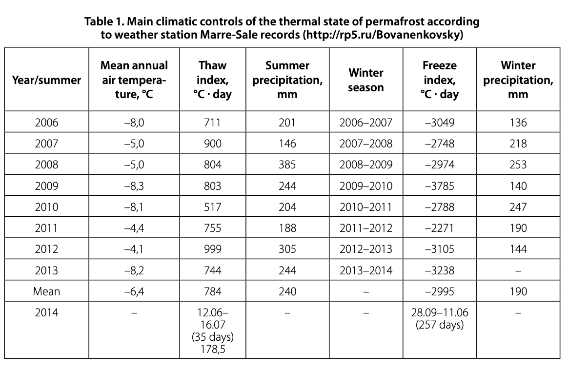
The central part of the Yamal Peninsula is limited by the Yuribei River in the south and the Nadui-Yakha River in the north, including areas of active gas extraction and transportation. The region is in the zone of continuous permafrost at least 300 m thick, with high tabular ground ice content. In the 2000s, noTable fluctuations of various climatic parameters have been observed (Table 1).
The summer of 2012 and the preceding winter of 2011-2012 were the warmest since 2006 (Table 1). Summer precipitation in 2012 was close to the maximum level for this period, though precipitation during the preceding winter was at a medium level.
The crateris located intheTundra bioclimatic zone, a subzone of typical tundra, about 17 km west of the Mordy-Yakha River and about 11 km south of Halev-To Lake (69°581М and 68°22'E). Rolling hills with altitude up to 52 m have gentle slopes descending to small ravines and lakes. The slopes are densely vegetated by willow shrubs up to 1.5 m high. Cryogenic landslides have disturbed the lake shores (Fig. 1 ).The crater is located on a small hill about 34 m above sea level.
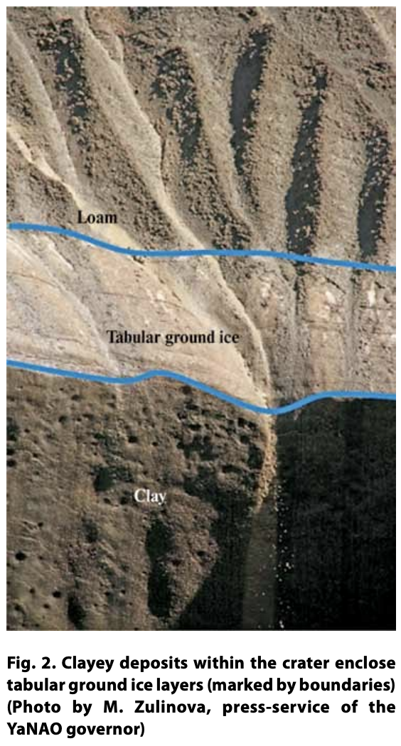
The crater area is within the zone of continuous permafrost. The average ground temperature may be as low as -6 °C, and the active layer is up to 1 m deep. The geological section is represented by silty-clayey deposits, rich in ice and organic matter, bearing several layers of tabular ground ice several meters thick (Ananieva, 1997, Fig. 2).
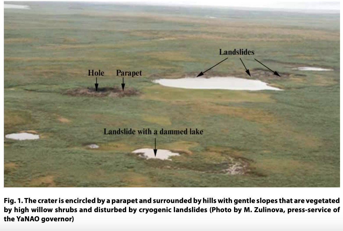
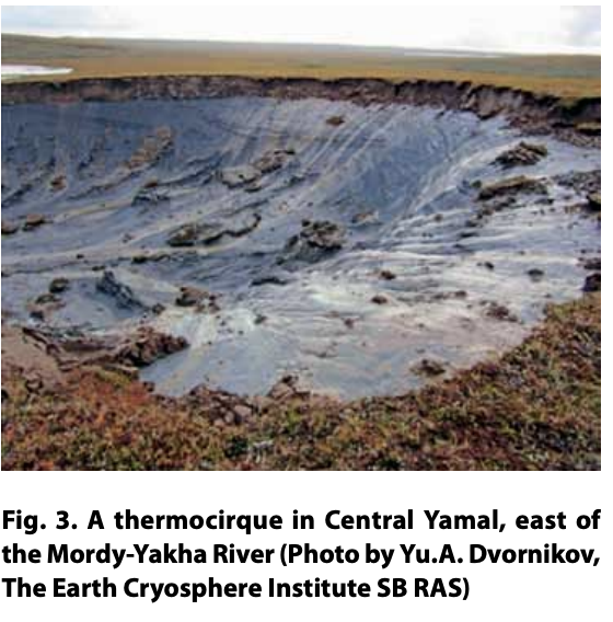
High ice content in the section, observed in the exposures at the shores of Halev-To Lake, is found in the crater's surroundings as well. This conclusion is based on the occurrence of cryogenic landslides, which created thermokarst lakes dammed by landslide bodies (see Fig. 1). Due to the considerable ice content in Central Yamal, a series of cryogenic processes are actively transforming the landscapes in both natural conditions and as a result of human activity [Walker et al., 2011; Kumpula et al., 2011; Gubarkov et al., 2012; Leibman et al., 2014; Khomutov et al., 2014]. Most impressive are the thermocirques, which appeared the last few years in Central Yamal (Fig. 3), [Leibman et al., 2014].They differ from the crater under discussion in having an outlet to a lake, and were triggered by the unusually warm temperatures in 2012.
STUDY METHODS
The crater was visited on July 16 and August 25, 2014. Close approach was impossible, so the crater was observed from the surrounding parapet. A GPS survey by GARMIN GPSmap 60Sx of the parapet and of the debris that was thrown quite far from the crater was undertaken. Distances were measured with a 30-m tape-line and a laser rangefinder Bosch GLM 250 VF Prof. The depth was measured with a tape and a rope with video camera dropped into the crater. The same camera allowed for a description of the walls deep in the hole, which the sun's light did not reach.
Also roughly measured were the methane concentration, with the help of a gas analyzer SGG-20 tuned to measure methane, and the gamma-radiation with a Geiger counter "SOEKS 01M" in the air around the crater and in the hole. A metal probe was used to measure the depth of the active layer. Professional photography and videography were performed.
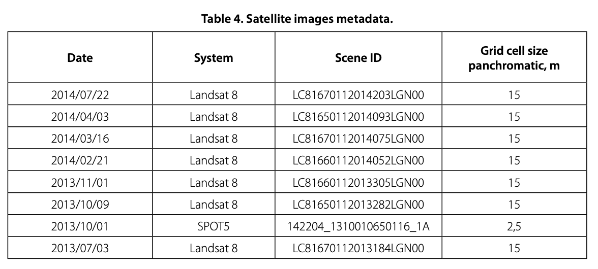
Landsat 8 and SPOT 5 satellite images for various time spans were interpreted to determine the time of crater formation. Landsat 8 satellite images were retrieved from the USGS database through the EarthExplorer service [httpWearthexplorer.usgs.gov].
A SPOT 5 satellite image was obtained from the archives of RDC "SCANEX" within the framework of the "Geoportal MSU" project.
RESULTS
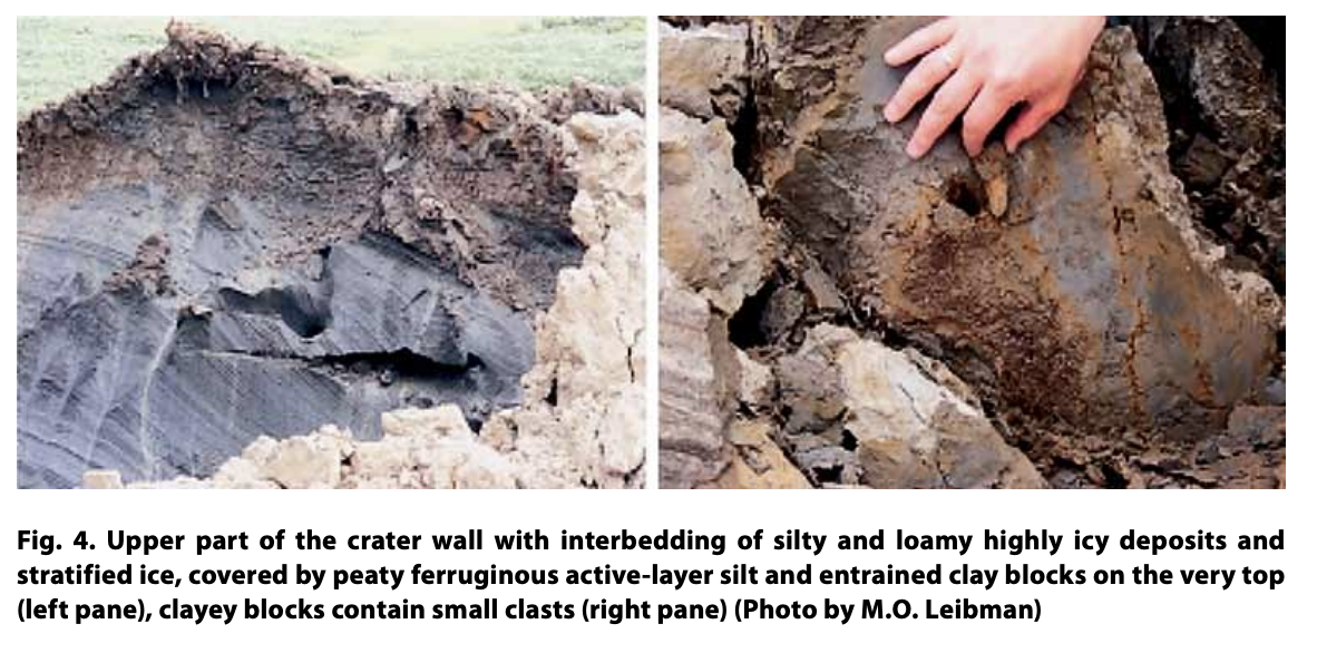
The landform under study is a crater of a depth about 2 times larger than its diameter, with almost vertical walls.The exposed walls consist of frozen ground, mainly clay, with ice lenses and layers in the lower part and ice of various transparency in the upper portion of the section.The upper 2 m of brownish silty-loamy sediments with peat inclusions represent an active layer covered by clay blocks thrown out of the hole. Below is a thin interbedding of silty and loamy deposits with high ice content (Fig. 4), or rather stratified ice with stratification close to vertical, underlain by dark grey clay with rare inclusions ofclasts (see Fig. 2 and 4).
The crater is surrounded by a parapet of thrown out silt, loam, clay and turf blocks. Red, highly ferruginous flat-block surfaces (see Fig. 4, right pane) are evidence of frozen deposits broken along the ice lenses, constituting the reticulate cryogenic structure intrinsic to the clays in the area [Ananieva, 1997].
The upper part of the hole has relatively gentle slopes descending to an overhang, passing downward to steeper slopes and finally to the small lake at the bottom. The shape and size of the walls are changing as the permafrost thaws more quickly where sunlight reaches, and more slowly in the depths of the hole. Runnels of meltwater cut the walls, gurgling down and forming a muddy lake at the bottom. Pieces of turf destabilized as the underlying permafrost thaws fall down with a rumble like that of cannon shot. Thus retreat of the hole's rim is very rapid, probably more than 1 m during the several hours of the July visit.
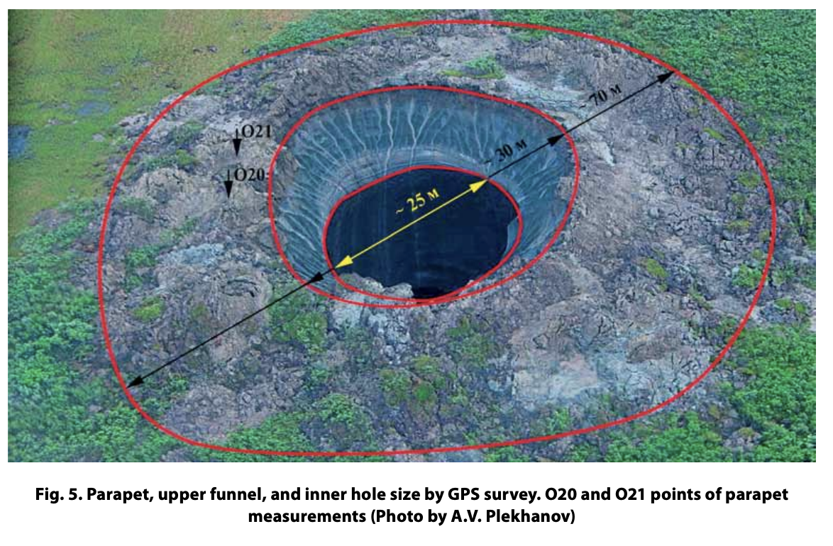
The diameter of the whole landform was estimated by GPS survey as approximately 70 m outside the parapet. The parapet's width is about 20 m, so the hole must have been no more than 30 m in diameter - less than that (about 25 m) excluding the overhang (Fig. 5). The depth of the hole could not be accurately measured but it exceeds the 50 m to which the rope was lowered and was possibly around 70 m on July 16 and much less (no more than 35 m) on August 25. The depth is changing as the crater fills with mud, turf and water from the thawing permafrost.
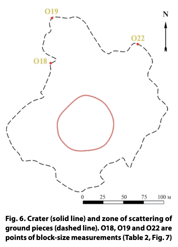
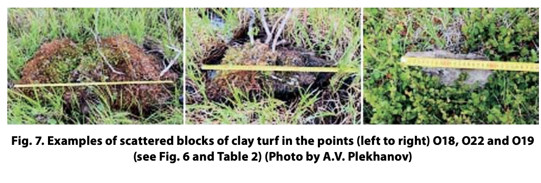
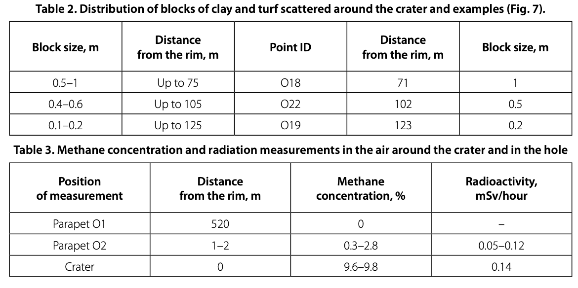
Clods of the clay and fragments of turf mat were thrown up to 120 m from the crater (Fig. 6). The farther from the crater, the smaller are the clay clods, from 1 m close to the parapet to several centimeters farthest from the crater. Fragments of turf mat 50- 100 cm in size are found up to 60 m away from the crater. Examples of measurements are presented in Table 2 and Fig. 7.
The volume of the parapet is approximately 2000 m3. At the same time, the volume of the void inside the hole is no less than 25,000 m3, which is more than 10 times the volume of the parapet. The difference is due to high ice content observed in the crater walls and constituting more than 80 % according to estimate at a glance.
Measurements of radioactivity and methane concentration are presented in Table 3.These measurements showed that radioactivity is at a normal level (0.05-0.14 mSv). Methane concentration range from 2.8-0.3 % outside the hole to 9.6-9.8 % inside the crater. Both values are much higher than normal, and within the crater the concentration is close to explosive (>5 %).
The depth to which the permafrost had thawed, an easily obtained characteristic of the state of permafrost, depends on the thickness of the organic layer, and was 53-66 cm in the lake depression with thick organic cover and 60-77 cm on a slope with willow shrubs and on the parapet. This depth is higher than average for this time of the year, possibly as a result of unusually high air temperatures in June 2014.
Some observations in the vicinity of the crater revealed the following. A lake located about 100 meters from the crater does not have a hydrological connection with it.The high cliffs of lake shore are disturbed by cryogenic landslides. This process occurred most actively in the 1980's [Ananieva, 1997] and serves as evidence of high ice content close to the surface.
DISCUSSION
The permafrost of Central Yamal contains a substantial amount of hydrocarbons in the depths from about 20 m to about 130 m [Rivkina et al., 2006; Rivkin, 1997; Chuvilin, 2007; Bondarev et al., 2008; Lein et al., 2003; Leibman et al., 2003; 2011; Streletskaya et al., 2014]. The depth of the Yamal hole is within this interval. Gas is enclosed in the ground ice and dissolved in unfrozen water. Gas hydrates, though unsTable, can be found at these depths as well in relict (metas Table) form. An increase in ground temperature in the last decade has caused a series of permafrost responses. Partial thaw of ground ice released gas enclosed in the ice [Muskett and Romanovsky, 2012]. Cryopegs respond to temperature and may dissolve the ice with relict gas hydrates and give start to accrescent gas release. Holes in the sea floor formed by similar processes and likewise surrounded by parapets are known as pockmarks [Hovland and Judd, 1988; Melnikovet al., 1997;Mironyuk and Otto, 2014].
Impossible and improbable explanations for the crater formation that can be rejected are: (a) thermokarst (because of the evidence of an uprush of deposits to the surface to form the parapet); (b) burst of pingo (because this would be expected with cooling temperatures and an increase of hydrostatic pressure in the ice-water core of the pingo; in addition, the presence of an ice core at a depth of at least 70 m would be improbable); (c) human activity (because no traces of human activity were observed in the vicinity of the crater); (d) gas combustion (because no traces of fire were observed in the crater or on the nearest slopes); (e) impact of a celestial body (the level of radioactivity is low, and there are no traces of heat; moreover, the pieces of clay are broken along the ice layers, not thawed, while at high temperatures they would have liquefied and formed flows on the surface instead of a parapet).
The features that must be explained are as follows. (1) The depth of the crater exceeds its diameter. (2) The levels of methane and hydrogen sulfide emissions from the permafrost exposed in the hole are high. (3) Clay clods were found at a distance of
120 m from the crater, decreasing in size with increasing distance from the parapet. At a given distance from the crater, larger pieces of turf were found than pieces of clay; turf is much less dense than clay. (4) New leaves on shrubs must have appeared after the parapet formed. At the same time, the hole is not yet filled with water from rain or melting ice.
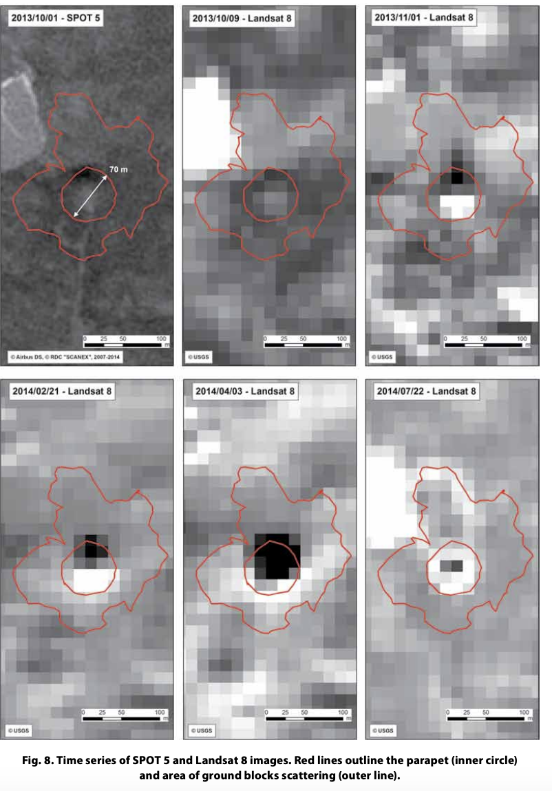
The age of the feature was determined through the comparison of images for several dates in 2013 and 2014. All available remote sensing data was georeferenced based on the SPOT 5 satellite image, which had the highest resolution of any available to the moment (Table 4). A GPS-track of the field survey conducted on July 16, 2014 was superimposed on the remote sensing data. The inner circle marks the outer limits of parapet. Its diameter is about 70 m. The outer line marks the area of in which clay blocks have been scattered (Fig. 8).
From the satellite images, we concluded that the crater was formed in the late 2013 or early 2014. One can see that at least until 2013/10/09 in the place of the crater, there is a hill 40-45 m in diameter. After 2013/11/01 satellite images yield a series of pixels of low reflectivity. The size of the area was increasing at least until 2014/04/03. Presumably this specific reflectivity results from water-saturated deposits entrained from the crater forming a parapet along with the hole itself. In summer, when the parapet partially dried up and the barren ground was more reflective, the crater area appeared as a bright ring surrounding the hole.
Thus, based on the remote sensing data, we assume that the crater was formed within the time range from 2013/10/09 to 2013/11/01.
Our hypothesis of crater formation is suggested by the relatively similar in origin features controlled by gassing in permafrost, the occurrence of tabular ground ice and permafrost's response to fluctuations in climate. The least inconsistent mechanism explaining all the observed manifestations is as follows. We expect existence of relict gas hydrates and cryopegs beneath the tabular ground ice bodies in the geological section on study. This suggestion is supported by observations in Central Yamal in thousands of boreholes [Yakushev et al., 2005; Streletskaya, Leibman 2003]. Increasing ground temperatures in the last decade, particularly in 2012, could have released gas both out of permafrost and bubbly facies of tabular ground ice, as well as from decay of gas hydrates. The last gives a large cataclysmic expansion.This expansion which may start from a slow process produces a landform close to the one known as pingo (hydrolaccolith). This form will serve as a limitation factor for localization of the future hole and determine its cylinder shape. In time as gas hydrate decomposition acquires its full strength, the "shot" pops up the frozen ground cover. Ground temperature lags behind air temperature, thus the warm summer of 2012 produced an effect on ground temperature a year later, most likely in the fall of 2013.
As gas in upper layers of permafrost is of bacterial origin [Rivkina et al., 2006; Streletskaya et al., 2014], its distribution over entire permafrost area is independent of the presence or absence of gas deposits within the area [Yakushev et al., 2005]. Thus such a process of gas hydrate expulsion may happen in other permafrost areas with the same favorable for gas hydrate conservation in the past and decomposition in modern times.
The thaw of the permafrost at the top of the hole initiates a process that will expand the hole and form a lake. Possibly, some Yamal lakes formed during the Holocene climatic optimum about 10,000 years ago and previously considered to be thermokarst lakes, formed through an analogous process.
CONCLUSIONS
The reconnaissance established the following:
- An exciting permafrost feature, a gasemission crater surrounded by a parapet no more than 30 m in diameter is observed;
- As water accumulates at the bottom of the hole, the feature has no access to deeper layers and the assumption that deep-seated gas deposits caused the crater is implausible;
- No traces of human activity in the vicinity of the crater were found, so this phenomenon is of a purely natural origin; (4) The date of the crater's formation is estimated to have been in the late fall of 2013; (5) The high concentration of methane in the hole, which decreases in the vicinity of the hole and is negligible far from the hole, indicates the role of methane in the formation of the crater; (6) No high background radiation and no traces of extremely high temperatures, which would point to a gas explosion or an extraterrestrial object such as a meteorite were observed.
It is highly probable that such landforms will be generated in the future in sui table geological and permafrost conditions. The origin of this crater is attributed to the anomalously warm summer of 2012, the increased ground temperature and amount of unfrozen water in the permafrost, expanding of cryopegs, formation of a pingo-like mound and its outburst due to high pressure produced by gas hydrate decomposition within permafrost. Similar temperature anomalies may increase in number in the future decades, presenting risks for human activities in the region.
Proving the hypothesis presented in the paper would require a full range of field, laboratory and remote-sensing studies.
ACKNOWLEDGEMENTS
The field study was organized according to the order of the Governor of Yamal-Nenets Autonomous District Dmitry Kobylkin by the Department of international and foreign economic relations under the auspices of the Russian Centerfor Arctic Development. Authors are grateful to the organizers: Deputy Governor, director ofthe Department of International and External Economic Relations of the Yamalo- Nenets Autonomous Region Mazharov A.V., to the participants of the expedition V.L. Sholya from the Ministry of Emergency Situations, A.N. Naumenko and M.A. Zulinova from the pressservice ofthe Governor. This work was funded by the Program of support of leading scientific schools RE SC-335.2014.5
Authors are indebted to Max Ehrenfreund from Washington Post for valuable comments and editing the manuscript, and anonymous reviewers for useful comments which improved the paper.
REFERENCES
- Ananieva, G.V. (1997) Specific features of engineering-geological conditions ofthe northern portion of railway Obskaya-Bovanenkovo. Results of fundamental studies ofthe Earth cryosphere in Arctic and sub-Arctic. Novosibirsk, Nauka, pp. 116-23 (in Russian).
- Are, F.E. (1998) Problem of deep gases emission into the atmosphere. Kriosfera Zemli (the Earth Cryosphere), II (4), pp. 42-50 (in Russian).
- Bondarev, V.L, Mirotvorsky, M.Y, Zvereva, V.B., Oblekov, G.I., Shajdullin, R.M. and Gudzenko, VT. (2008) Gas-chemical characteristics of above-Senoman deposits of Yamal pen
insula (case study at Bovanenkovo gas-condensate deposit. Geology, geophisics and development of oil and gas deposits. 5, pp. 22-34 (In Russian). - Cardyn, R., Clark, I.D., Lacelle, D., Lauriol, B., Zdanowicz, C. and Calmels, F. (2007) Molar gas ratios of air entrapped in ice: A new tool to determine the origin of relict massive ground ice bodies in permafrost. Quaternary Research, 68, pp. 239-48.
- Chuvilin, E.M. (Ed.) (2007) Structure and properties of rocks in cryolithozone of the southern part of Bovanenkovo gas-condensate deposit. Moscow, GEOS, 137 p. (in Russian).
- Gilichinsky D., Rivkina E. and Samarkin V. (1997) The ancient viable microorganisms and radiative gases in West Beringia Permafrost: Research opportunities for Paleoecological implications and Forecast. In: M. Edwards, A. Sher and D. (Eds), Gutry Terrestrial paleoen- vironmental studies in Beringia, Fairbanks, Alaska, pp. 134-45.
- Gubarkov, A.A., Leibman, M.O. and Khomutov, A.V. (2012) Cryogenic processes in natural and technogenic conditions of Kharasavey gas field.Transactions of the High School. Oil and Gas, 3, pp. 21 -7 (in Russian).
- Hovland, M. and Judd, A.G. (1988) Seabed Pockmarks and Seepages: Geological Ecological and Environmental Implication. Springer
- Hovland, M., Gardner, J.V. and Judd, A.G. (2002) The significance of pockmarks to understanding fluid flow processes and geohazards. Geofluids, 2, pp. 127-36.
- Hovland, M. and Judd, A.G. (1992) The global production of methane from shallow submarine sources. Continental Shelf Research, 12 (10), pp. 1231-1238.
- Khomutov, A.V. and Khitun, O.V. (2014) The dynamics of vegetation cover and active layer depth in the typical tundra of Central Yamal under technogenic impact. Tyumen State University Herald, 4. pp. 17-27.
- Ku три la, T, Pajunen, A., Kaarlejärvi, E., Forbes, B.C. and Stammler, F. (2011) Land use and land cover change in Arctic Russia: Ecological and social implications of industrial development. Global Environ. Change, 21 (2), Elsevier, pp. 550-562.
- Leibman, M., Khomutov, A. and Kizyakov, A. (2014) Cryogenic landslides in the West- Siberian plain of Russia: classification, mechanisms, and landforms. In: W. Shan et al (Eds.) Landslides in Cold Regions in the Context of Climate Change, Environmental Science and Engineering, Switzerland, Springer International Publishing, pp. 143-162.
- Leibman, M.O., Kizyakov, A.I., Lein, A.Yu., Perednya, D.D., Sawichev, A.S. and Vanshtein, B.G. (2011) Sulfur and Carbon Isotopes within Atmospheric, Surface and Ground Water, Snow and Ice as Indicators of the Origin ofTabular Ground Ice in the Russian Arctic. Permafrost and Periglacial Processes, 22 (1), pp. 39-48.
- Leibman M.O., Hubberten H.-W., Lein A.Yu., Streletskaya I.D. and Vanshtein B.G. 2003. Tabular ground ice origin in the arctic coastal zone: cryolithological and isotope-geo- chemical reconstruction of conditions for its formation. In: M. Phillips, S.M. Springman and L.U. Arenson (Eds.) Proc, of the 8th I nt. Conf, on Permafrost, (Zurich, Switzerland, 21-25 July 2003), vol. 1, Lisse, Netherlands: A.A. Balkema Publishers, pp. 645-650.
- Lein, A.Yu., Sawichev, A.S., Leibman, M.O., Miller, Yu.M. and Pimenov, N.V. (2003) Isotopicbiogeochemical peculiarities of tabular ground ice of Yugorsky and Yamal peninsula. In: M. Phillips, S.M. Springman and LU. Arenson (Eds.) Proc, of the 8th I nt. Conf, on Permafrost (Zurich, Switzerland, 21-25 July 2003), vol. 2, Lisse, Netherlands, A.A. Balkema Publishers, pp. 661-666.
- Melnikov, VP, Spesivtsev, VI. and Kulikov, VI. (1997) On fluid degassing of hydrocarbons as a source of new ice formation on the Pechora sea shelf. Results of fundamental studies of the Earth cryosphere in Arctic and sub-Arctic, Novosibirsk, Nauka, pp. 259-269 (in Russian).
- Mironyuk, S.G. and Otto, V.P. (2014) Gas-saturated seabed grounds and natural hydrocarbon gassings: regularities of distribution and engineering construction hazards J. Georisk (In press) (In Russian).
- Muskett, R. and Romanovsky, V.E. (2012) Multi-Satellite-Derived Changes in Energy and Mass of Russian Permafrost Regions. In: K.M. Hinkel (Ed.) Proc, of the 10th I nt. Conf, on Permafrost, vol. 1, Salekhard, Russia, The Northern Publisher, pp. 277-282.
- Rivkin, EM. (1997) Results of the study of methane emission along the pipeline Nadym- Punga (North of West Siberia). Results of fundamental studies of the Earth cryosphere in Arctic and sub-Arctic, Novosibirsk, Nauka, pp. 165-168 (in Russian).
- Rivkina, E.M. and Gilichinsky, D.A. (1996) Methane as a palaeoindicator of the origin and dynamics of permafrost. Litologia I poleznye iskopaemye (Lithology and mineral resources), 4, pp. 183-193 (in Russian).
- Rivkina, E.M., Kraev, G.N., Krivushin, K.V., Laurinavichus, K.S., Fedorov-Davydov, D.G., Kholodov, A.L., Shcherbakova, V.A. and Gilichinsky, D.A. (2006) Methane in permafrost of the North-Eastern sector of the Arctic. Kriosfera Zemli (the Earth Cryosphere), X (3), pp. 23-41 (in Russian).
- Rokos, S.l. (2009) Gas-saturated deposits of the upper part of Barents-Kara shelf. Candidate of geographic sciences thesis, Murmansk (in Russian).
- Skorobogatov, V.A., Yakuchev, V.S. and Chuvilin, E.M. (1998) Sources of natural gas within permafrost North-West Siberia. Proc, of the 7th I nt. Conf, on Permafrost, Yellowknife, Canada, Univ. Laval Collection Nordicana, N55, pp. 1001-1006.
- Streletskaya, I.D. and Leibman, M.O. (2003) Cryogeochemical model of tabular ground ice and cryopegs formation at central Yamal, Russia. In: M. Phillips, S.M. Springman and L.U. Arenson (Eds.) Proc, of the 8th I nt. Conf, on Permafrost (Zurich, Switzerland, 21-25 July 2003) vol. 2, Lisse, Netherlands: A.A. Balkema Publishers, pp. 1111-1115.
- Streletskaya, I., Vanshtein, B., Vasilev, A. and Oblogov, G. (2014) Methane in the gas bubbles in the ground ice near Marre-Sale polar station, West Yamal, Russian Arctic. Book of Abstracts of EUCOP4 - 4th European Conf, on Permafrost (Evora, Portugal, 18-21 June 2014), p. 274.
- Vanshtein, B.G., Cherkashov, G.A., Piven, P.l. and Leibman, M.O. (2003) Cryogeochemical fields in tabular ground ice as indicators of its origin. In: M. Phillips, S.M. Springman and L.U. Arenson (Eds.) Proc, of the 8th I nt. Conf, on Permafrost (Zurich, Switzerland, 21-25 July 2003) vol. 2, Lisse, Netherlands: A.A. Balkema Publishers, pp. 1155-1160.
- Walker, D.A., Forbes, B.C., Leibman, M.O., Epstein, H.E., Bhatt, U.S., Comiso, J.C, Drozdov, D.S., Gubarkov, A.A., Jia, G.J., Karlejaärvi, E„ Kaplan, J.O., Khumutov, A.V., Kofinas, G.P., Ku три la, T, Kuss, R, Moskalenko, N.G., Raynolds, M.K., Romanovsky, VE., Stammler, F. and Yu, Q. (2011) Cumulative effects of rapid land-cover and land-use changes on the Yamal Peninsula, Russia. In: G. Gutman and A. Reissel (Eds.) Eurasian Arctic Land Cover and Land Use in a Changing Climate, vol. VI, New York, Springer, pp. 206-236.
- Uchida,T.,Takeya,S., Chuvilin, E., Ohmura, R., Nagao, J.,Yakushev,V, Istomin,V, Minagawa, H., Ebinuma,T„ Narita, H. (2004) Decomposition of methane Hydrates in sand, sandstone, c lays and glass beds // J. Geoth. Res., 109, B05206.
- Yakushev, V.S. (2009) Natural gas and gas hydrates in cryolithozone, Moscow, VNIIGAS, 192 pp. (in Russian).
- Yakushev, V.S., Perlova, E.V, Makhonina, N.A. (2005) MetasTable (relic) gas hydrates: spreading, resources, prospects and development. Kriosfera Zemli (the Earth Cryosphere), IX (1), pp. 68-72 (in Russian).